The Thing That Skimmed the Aegean (DOW-UAP-PR34, October 2023)
An Air Force special operations Reaper crew, an hour out of Larissa on the night of 26 to 27 October 2023, watched something skim the surface of the Aegean and throw a run of ninety degree turns at an estimated eighty miles an hour, then lost it into the water three minutes later.
What did witnesses see at The north central Aegean Sea?
The sortie is documented down to the minute, because the Department of War declassified the crew's own mission report alongside the video. The report is MISREP 9329374. The aircraft took off from LGLR at 262339:00ZOCT23, which is Larissa Air Base in Thessaly, central Greece, at 23:39 Zulu on 26 October 2023. Control was handed over from the launch and recovery element about thirteen minutes later, the aircraft flew a tasked intelligence, surveillance and reconnaissance mission, and it finally landed at OJMS at 271309:00ZOCT23, that is Muwaffaq Salti Air Base at Azraq in eastern Jordan at 13:09 Zulu on 27 October. Total mission time was 13 hours 30 minutes, of which 6 hours 29 minutes were full motion video hours. The takeoff remark in the report explains the leg in one line: the aircraft had "TRANSITED AND LANDING AT OJMS TO REPLACE THE LIGHTNING LINE THAT LANDED AT LGLR YESTERDAY." Weather was logged CLEARWX and mission effectiveness SATISFACTORY.
Fifty six minutes after takeoff, while the aircraft was still transiting east across the Aegean toward its tasked area, the sensor operator saw something. The report's UAP block gives the initial contact time to the second as 270035:12ZOCT23, and the free text section states it flatly: "AT 0035Z [redacted] WAS EN ROUTE TO THEIR TARGET WHEN THEY SPOTTED A UAP FLYING JUST ABOVE THE SURFACE OF THE OCEAN WATER. THE UAP TOOK MULTIPLE 90 DEGREE TURNS AT AN ESTIMATED 80 MPH. AT 0038Z [redacted] LOST THE UAP FROM THEIR FEED." Three minutes and change, start to finish.
The structured fields on the form are the interesting part, because they are the crew's own answers to a checklist rather than a story anyone chose to tell. Under UAP Description the operator wrote "SEEMINGLY CIRCULAR, TOO SMALL TO MAKE OUT DETAILS". Under UAP Maneuverability Observations, "Sharp 90 degree turns". Kinetic Velocity, "80 MPH", with the accompanying Kinetic Velocity Accuracy field set to "Estimated", as is every other kinetic field on the sheet. UAP Physical State, "Solid". UAP Propulsion Means, "UNK". UAP Signatures, "NONE". UAP Response to Observer Actions, "NONE". Number of UAP Sighted was left blank, altitude and depth and trajectory blank, the interrogation field blank, and the entries for objects recovered, effects on persons, effects on equipment and observer engagement of the UAP are all negative. First and last coordinates are given as MGRS grid references with a first seen radius and last seen radius of 5, both flagged as estimated.
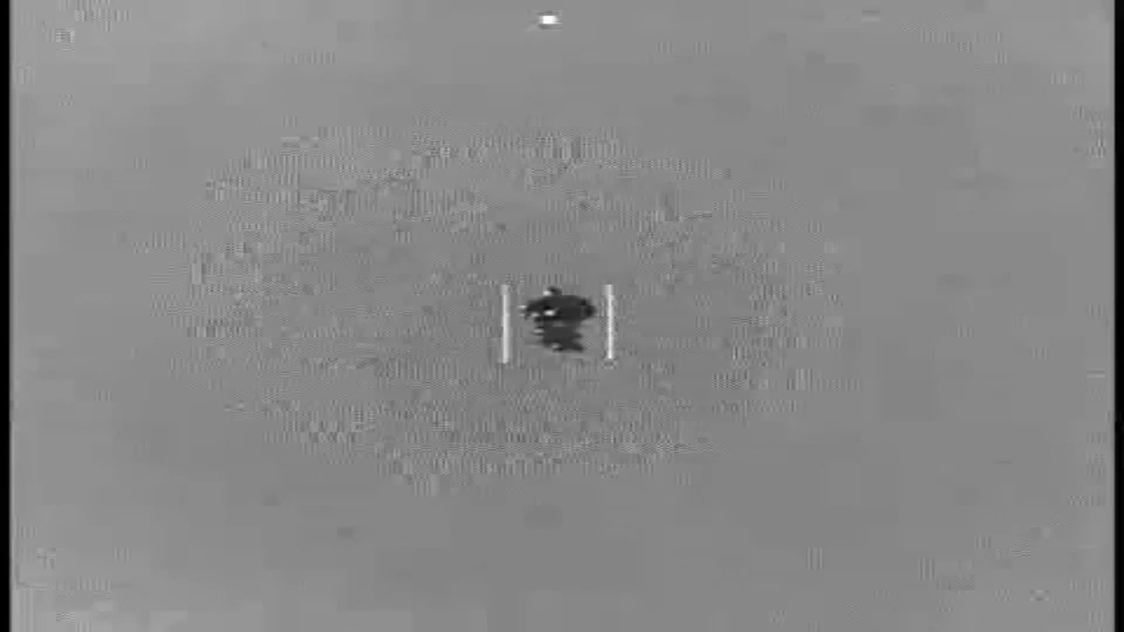
The video the Department released with it runs two minutes and fifty seven seconds and is an infrared feed, and its own description is written by the Department's analysts frame by frame. "00:04: An area of contrast enters the sensor field-of-view from the bottom left quarter of the screen. 00:07-00:19: The area of contrast moves back and forth horizontally across the field-of-view as the sensor pans to track it. 00:20-01:00: The area of contrast remains generally centered within the sensor field-of-view. 01:00-02:01: The sensor designates the area of contrast with a blue reticle, synchronizing its motion with the area of contrast's relative position. 02:02-02:21: The sensor engages a contrast filter to better differentiate the area of contrast from the background. 02:22: The area of contrast becomes indistinguishable against the background, and the reticle drops its lock. 02:27-02:57: After losing lock, the sensor rapidly cycles zoom levels and contrast thresholds." That last sequence matters. The object did not fly away and it was not lost to a turn. It stopped being distinguishable from the sea at the exact moment the operator changed the contrast handling, and the reticle let go.
On where it happened, the mission report is redacted but not silent. The friendly aircraft location and both the first and last UAP coordinates are given as military grid references beginning 35S KD, with the numeric digits blacked out. That designator alone fixes a 100 kilometre square. Grid zone 35 spans 24 to 30 degrees east, the K easting column in that zone covers 200,000 to 300,000 metres, and the D northing row in an odd numbered zone within latitude band S resolves to 4,300,000 to 4,400,000 metres. Converted, the square runs from about 38.80 to 39.73 degrees north and 23.50 to 24.70 degrees east, which is the north central Aegean around Skyros and the Northern Sporades, between the Euboean coast and Lemnos, somewhere between 88 and 213 kilometres from the runway the aircraft had left 56 minutes earlier. That is the archive's own computation from a partially redacted grid designator, so treat it as a derivation rather than a published coordinate. It does, though, land independently in the same water that the Department's release manifest names for this file: Aegean Sea.
More footage and images of this sighting
DOW-UAP-D033, the seven page declassified aircrew mission report (MISREP 9329374) paired with this video, declassified by MG Richard A. Harrison, USCENTCOM Chief of Staff, on 22 January 2026. Recovered from the Wayback Machine because war.gov refuses ordinary requests. View source
The Department of War's machine readable manifest for PURSUE Release 01, the only published source of incident location and incident date for these records. Its row for DOW-UAP-D033 gives Incident Date 10/27/23 and Incident Location Aegean Sea, while its row for the paired video DOW-UAP-PR034 gives N/A and Greece. View source
What is the official explanation?
This record exists because of a policy, not because anyone in Greece asked a question. On 19 February 2026 President Donald Trump posted on Truth Social that he would be "directing the Secretary of War, and other relevant Departments and Agencies, to begin the process of identifying and releasing Government files related to alien and extraterrestrial life, unidentified aerial phenomena (UAP), and unidentified flying objects (UFOs)". The resulting programme is the Presidential Unsealing and Reporting System for UAP Encounters, or PURSUE, hosted at war.gov/UFO, and the Department is unusually careful about what the archive is. Its own framing reads: "The materials archived here are unresolved cases, meaning the government is unable to make a definitive determination on the nature of the observed phenomena. This can occur for a variety of reasons, including a lack of sufficient data, and the Department of War welcomes the application of private-sector analysis, information and expertise." Secretary of War Pete Hegseth's accompanying statement says the release "demonstrates the Trump Administration's earnest commitment to unprecedented transparency". The first tranche of 162 files was cleared for release on 8 May 2026, followed by tranches on 22 May, 12 June and 10 July 2026.
The Aegean file sits in that first tranche, and the timestamp is how you know. The DVIDS record for DOW-UAP-PR34 is video ID 1006080, VIRIN 231002-D-D0360-6858, filename DOD_111689011, length 00:02:57, and its Date Posted reads 05.08.2026 07:48. DVIDS renders dates month first, so that is 8 May 2026, which is release 01. Do not try to read the tranche off the content delivery path: the file sits in the 2605 directory, and so do release 02 records. The Date Posted stamp is the one that settles it. One other detail on that page is worth flagging, because it is not the norm. Most PURSUE video records carry no location at all, or read as an undisclosed location. This one has a Location field, and it reads "GR".
The paired document is the substance. DOW-UAP-D033, "Mission Report, Greece, October 2023", is a seven page scan of the aircrew's MISREP, published as a PDF on war.gov and recoverable through the Wayback Machine because war.gov refuses ordinary fetching. Its cover markings are explicit: "Declassified by MG Richard A. Harrison, USCENTCOM Chief of Staff, Declassified on 22 January 2026", with every page footed "USCENTCOM MDR 26-0019, Approved for Release to AARO, 01/26/26". The report's own original classification block had set a declassification date of 20481026, which is to say 26 October 2048, twenty five years after the flight. The redactions across the pages carry the exemption codes 1.4a, 3.5c, (b)(3), 130b and (b)(6), which cover military plans and operations, intelligence sources and methods, statutorily protected information, and personal privacy.
The administrative block also answers a question the title raises. Greece is not in United States Central Command's area of responsibility, and yet the DVIDS blurb opens "The United States Central Command submitted a report". The mission report explains it without any drama. The combatant command field reads USCENTCOM, the major command field reads AFSOC, the reporting unit is the 33 SOS and the wing entry is 27 SOW, and the aircraft's own leg that night ran from a Greek base to a Jordanian one. This was a Central Command tasked special operations aircraft repositioning through the Aegean, so the sighting was reported up the chain that owned the aircraft rather than the chain that owns the airspace. The other entries fill the picture in: mission type ISR and AREC, primary sensor FMV, data link LINK 16, additional avionics AWGMESH, targeting pod "AN/DAS-4", operations centres listed as the 603rd and the 609 CAOC, and the campaign line "GCP - VEO (violent extremist group)". The Air Force's own fact sheet for the 33rd Special Operations Squadron says the unit "Operates MQ-9A aircraft, personnel, and equipment to provide persistent armed intelligence, surveillance, and reconnaissance" and has been assigned to the 27th Special Operations Group at Cannon Air Force Base since 2009, and the Air Force MQ-9 fact sheet notes that the aircraft's baseline system is the Multi-Spectral Targeting System, the MTS-B, which "integrates an infrared sensor, color, monochrome daylight TV camera, shortwave infrared camera, laser designator, and laser illuminator". The aircraft type itself is redacted in the report. On the strength of the unit, the wing, the pod, the launch and recovery element handover and the thirteen and a half hour endurance, this archive reads the platform as an MQ-9, and says so as an inference rather than as a published fact.
The dating is where two official surfaces contradict each other, and the honest thing is to publish both rather than choose. The DVIDS page gives Date Taken 10.01.2023. The release manifest's own row for the video, DOW-UAP-PR034, gives Incident Date "N/A" and Incident Location "Greece". The manifest's row for the paired document, DOW-UAP-D033, gives Incident Date 10/27/23 and Incident Location "Aegean Sea". The mission report itself timestamps the contact 270035:12ZOCT23. Two of those four are placeholders and it is provable rather than assumable. The sibling record DOW-UAP-PR35 carries the identical Date Taken of 10.01.2023, yet the manifest dates its paired document DOW-UAP-D035 to 29 October, a different day entirely, and DOW-UAP-PR28 carries 01.01.2024 against a paired document dated 25 January 2024. The DVIDS Date Taken is a first of the month stamp. The VIRIN date, 231002, falls a day after the incident and is a production artefact. So October 2023 is real and published by the Department, 27 October 2023 is supported by the two sources that actually carry a day, and 1 October 2023 is an artefact that should never have entered circulation.
That manifest, incidentally, is the only published source of incident location for this corpus, and it needs a caveat every time it is used. It runs 158 rows and its location column is ragged: 43 rows read N/A, four are blank, the grain jumps between a country and a sea and a city from row to row, and at least two rows disagree with their own titles. DOW-UAP-D005 is titled "Mission Report, Arabian Gulf, 2020" and its location cell reads "Mediterranean Sea", and DOW-UAP-PR045 is titled "Middle East, 2020" with a location cell reading "Southern United States". For the Greek group it is at least internally consistent about the water: three video rows say "Greece", and their three paired document rows say "Aegean Sea" twice and "Mediterranean Sea" once.
As of the writing of this file the All-domain Anomaly Resolution Office has published no analysis of this incident, and no Greek authority has said anything about it at all. The Hellenic Air Force, the Hellenic National Defence General Staff and the Ministry of National Defence have all been silent on the record, in Greek or in English, across the Greek coverage traced for this file.
What did the witnesses think it was?
There is no witness account here in the ordinary sense, and that absence is itself the shape of the record. The crew never saw the Aegean. They were sitting in a ground control station, flying an aircraft that had been handed to them by a launch and recovery element thirteen minutes after it left Larissa, watching a monochrome feed. Their names are gone: the report lists a point of contact at the rank of Airman First Class, a quality control checker at Senior Airman and an approver at Staff Sergeant, and every name, phone number and email is blacked out under the privacy exemptions. What survives of their judgement is what they ticked on a form during or shortly after a thirteen and a half hour sortie.
What they ticked is notably unexcited. Under "Observer Assessment of UAP" the entry reads "Benign". Under "UAP Under Intelligent Control (yes/no; if yes, describe)" the entry reads "NO". Under "UAP Signatures", "NONE". Under "UAP Advanced Capabilities And/Or Materials", "UNK". This is worth dwelling on, because it runs directly against the way the record has been read in the press. The people who actually watched the thing recorded that it was small, circular, too small to resolve, thermally unremarkable, harmless, and in their assessment not under intelligent control. They logged the ninety degree turns because the form asked about manoeuvrability and that is what the turns looked like, and they logged eighty miles per hour with the accuracy field set to estimated because there was no ranging solution to do better. They filed it and they flew on to Jordan. Nobody in this document is claiming anything.
The corroboration, such as it is, comes from the corpus rather than from the Aegean. Two days later a second Greek report was filed and released as DOW-UAP-PR35 with its own mission report DOW-UAP-D035, dated 29 October 2023 in the manifest and also placed in the Aegean Sea. Its blurb describes a UAP "flying just above the surface of the ocean", the same phrase, this time "small and circular, flying near the surface of the ocean toward land", and in that clip too the object "becomes indistinguishable" as the background shifts from water to land. A third Greek record, DOW-UAP-PR28 with mission report DOW-UAP-D025, is dated 25 January 2024 in the manifest and placed in the Mediterranean Sea. That one is stranger: the object was described as diamond shaped with a non manoeuvring probe below it, estimated at "approximately 434 knots (499 mph)", and, in the reporter's account, "only visible when viewed via an onboard Short-Wave Infrared (SWIR) sensor". Three Greek reports from the same command in the same release, two of them 48 hours apart, are the strongest thing this case has going for it, and they are not the same event. This page covers 27 October only.
The civilian witnesses to this case are journalists, and they were downstream of a spreadsheet. Greek coverage broke on the day of the release: Newsbomb ran a piece by Panagiotis Velissaris on 8 May 2026 setting out the Greek entries, the defence site OnAlert carried the wire version the same day, aigaionews.gr followed on 9 May with a piece by Vangelis Maragkos that correctly reported the manifest's incident dates of 27 and 29 October 2023, and Cretalive returned to the story on 23 May when the second tranche landed. The German language Crete outlet Kreta Tipp published "Freigegebene US-Akten enthullen UFO-Sichtungen uber der Agais" on 9 May 2026 under the byline Kretaner (Norman), crediting Cretalive as its source and naming DOW-UAP-PR35 rather than PR34. The reporting has two consistent faults worth recording. Several outlets shuffled the document numbers, attaching the diamond shaped January 2024 object to D035 and the October object to D025. And several published 1 October 2023 as the date of this incident, which is the DVIDS Date Taken field read literally, and which the Department's own paired document contradicts by twenty six days. Not one Greek outlet obtained a comment from the Hellenic Air Force, the Hellenic National Defence General Staff or any serving officer, and not one connected the record to the American MQ-9 detachment that had been operating out of Larissa Air Base since late November 2022 under the United States and Greece Mutual Defence Cooperation Agreement, which is where the aircraft in this report took off from.
Is the Thing That Skimmed the Aegean (DOW-UAP-PR34, October 2023) real? The two-pass assessment
Pass one. Assume there is nothing unusual here at all, and see how far that gets, because it gets a long way.
The fatal weakness of this record is that there is no range. A gimballed electro optical and infrared ball on an aircraft gives you a bearing and an apparent size and an apparent rate, and nothing else. Without a laser range solution or a radar return there is no way to convert any of it into a real distance, a real size or a real speed, and the mission report knows this perfectly well: every kinetic field on the sheet is flagged "Estimated", the altitude, depth and trajectory fields are left empty, and the interrogation field is blank, meaning nothing was queried and nothing answered. The eighty miles per hour and the ninety degree turns are the operator's read of pixels moving across a screen. If the object was closer than assumed, the speed collapses and the turns become the ordinary jinking of something small and near. That is not a criticism of the crew, it is the standing limitation of the sensor, and it applies to every clip in this corpus.
Birds have to be taken seriously and usually are not. The north central Aegean in late October carries heavy seabird activity, and shearwaters in particular fly exactly the profile described here: a few metres above the water, in sharp banking turns, small and circular in a low resolution infrared frame, and thermally close to their background over an autumn sea that has not yet given up its summer heat. The single most diagnostic line in the entire record is the Department's own note that at 02:22 "the area of contrast becomes indistinguishable against the background" precisely when the operator engaged a contrast filter to try to sharpen it. That is the behaviour of a thermally weak target, not of something running an engine. A bird is thermally weak. So is a piece of floating debris, so is a whitecap on a choppy sea, and so is a spume plume.
Drones are the strongest conventional candidate and this file should say so plainly rather than hedging. The Aegean is one of the most heavily surveilled and most heavily flown stretches of water in Europe. Greek and Turkish military aviation operate there daily, Turkish and Greek unmanned aircraft patrol it continuously, NATO exercise traffic crosses it, and in the autumn of 2023 the sea also carried sustained irregular small boat and smuggling activity with its own drone component. A small unmanned aircraft is capable of eighty miles per hour, is capable of sharp turns, is small enough to be unresolvable at range on an MTS class sensor, and is thermally faint from above. Nothing in this record excludes one. There is no radar correlation published, no transponder interrogation, no second sensor, and no imagery beyond the clip. If somebody with a name published a specific evidenced identification of a specific aircraft over that grid square that night, this case would move tiers immediately. Nobody has.
The last prosaic strand is the sensor itself. Apparent motion in a gimbal is not object motion. The platform is flying, the ball is slewing, the field of view is being narrowed and widened by an operator, and any of those can put lateral movement into a stationary or slow object and, in the classic failure, can make a distant point source bloom into an apparently structured shape. Mick West and the Metabunk community have argued exactly this at length about the earlier Navy infrared releases, and this archive already carries that argument on its own gimbal page and stays consistent with it here. The Department's own frame log records the sensor panning to track, zooming, designating with a reticle, then rapidly cycling zoom levels and contrast thresholds after losing lock. That is a machine and an operator working hard on a marginal target, and a marginal target is where artefacts live.
Pass two. What survives all of that.
The provenance survives it. This is not a story told later to a researcher, it is a standardised operational form filled in by a serving aircrew during a tasked mission, filed through the reporting chain, and only made public two and a half years afterwards by a declassification action signed by a named general officer. Nothing in it reads as performance. The operator's own conclusions were that the object was benign and that it was not under intelligent control, which is the opposite of a claim being inflated. The record survived a Central Command mandatory declassification review, was released to the All-domain Anomaly Resolution Office, and was published with the video intact rather than as a paper summary.
The observation survives it too, in a limited way. This was not a two second glimpse. The object entered the frame at four seconds, was tracked for a minute of horizontal movement, held near centre for forty seconds, then held under an active reticle lock for a full minute, which means the tracker was successfully synchronising to it rather than to noise. Three minutes of continuous attention by a professional sensor operator on a professional sensor is not nothing, and a bird or an artefact that holds a reticle lock for sixty seconds is a bird or an artefact worth explaining rather than waving at.
The pattern survives it as well. Two Aegean reports forty eight hours apart, from the same command, described in near identical terms, plus a third off Greece in January 2024 whose reported property, visibility only in the shortwave infrared band, is genuinely peculiar and is not a property birds have. A pattern is context, not evidence, and it cannot do the work of a range gate on this specific clip. But three unresolved reports from one theatre in one release is a fact about the record, and the Department chose to leave all three of them unresolved.
And the official position survives it. Central Command investigated far enough to file and forward, AARO reviewed it, and the Department of War published it under a heading that says in its own words that it is unable to make a definitive determination on the nature of the observed phenomena. This archive's standing rule is that an official debunk is a claim with its own evidence tier and never a verdict. Here the apparatus did not even attempt a debunk. It declined to identify the object, published the raw video, and invited outside analysis.
The verdict is Unknown. There is no official narrative to dispute, because the Department has explicitly declared there isn't one. There is no named civilian analyst who has published a specific, method shown identification of this particular clip. A small uncorrelated drone or a seabird over the Aegean is a plausible reconstruction and this file has argued both at length, but a plausible reconstruction is not a positive identification of the specific real world object, and under this archive's rules that is the threshold a disputed tier has to clear. The case stands where the Department left it: a three minute infrared clip of something small and circular skimming Greek water on the night of 26 to 27 October 2023, tracked, locked, and then lost into the sea it was flying over.
Sources
- www.dvidshub.net/video/1006080/dow-uap-pr34-unresolved-uap-report-greece-october-2023
- d34w7g4gy10iej.cloudfront.net/video/2605/DOD_111689011/DOD_111689011.mp4
- web.archive.org/web/20260512084007if_/https://www.war.gov/medialink/ufo/release_1/dow-uap-d33-mission-report-greece-october-2023.pdf
- web.archive.org/web/20260512191840if_/https://www.war.gov/Portals/1/Interactive/2026/UFO/uap-release001.csv
- web.archive.org/web/20260805163450/https://www.war.gov/UFO/
- www.dvidshub.net/video/1006082/dow-uap-pr35-unresolved-uap-report-greece-october-2023
- www.dvidshub.net/video/1006073/dow-uap-pr28-unresolved-uap-report-greece-january-2024
- web.archive.org/web/20250201164740if_/https://www.cannon.af.mil/Portals/85/33%20SOS%20Fact%20Sheet%20CORRECT%2018MAY21.pdf
- web.archive.org/web/20260101083312/https://www.af.mil/About-Us/Fact-Sheets/Display/Article/104470/mq-9-reaper/
- www.defensenews.com/global/europe/2022/12/13/upgraded-greek-air-base-serves-growing-interest-for-us-drones/
- www.airandspaceforces.com/us-mq9-gaza-israel-hamas-war/
- www.newsbomb.gr/kosmos/story/1734381/arxeia-pentagonou-gia-atia-oi-anafores-gia-theaseis-kai-stin-ellada-deite-ta-vinteo
- aigaionews.gr/aporrita-vinteo-ufo-pano-apo-to-aigaio-apokalyptei-to-pentagono-video/
- www.onalert.gr/kosmos/to-amerikaniko-pentagono-evgale-sto-fos-aporrita-archeia-gia-ta-ufo-ti-eidan-stin-ellada/672942/
- www.cretalive.gr/kosmos/ipa-sti-dimosiotita-nea-arheia-gia-ta-ufo-treis-anafores-gia-tin-ellada-sta-eggrafa-toy
- www.kretatipp.de/freigegebene-us-akten-enthuellen-ufo-sichtungen-ueber-der-aegaeis/
- davidmegginson.github.io/ourairports-data/airports.csv
More cases from this region: UFO sightings in Greece