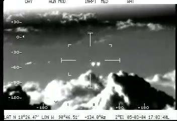
The Djibouti Infrared UAP Video: DOW-UAP-PR043 and the Avi Loeb Missile Claim (2025)
Two seconds of infrared video from a US military platform over southern Djibouti, released by the Department of War in its first PURSUE tranche on 8 May 2026 and logged as unresolved. In August 2026 the Harvard astrophysicists Devesh Nandal and Avi Loeb published a terrain stabilized reconstruction concluding that a fast tactical missile is physically compatible with the data. Within two days another named analyst, Mick West, published a camera fit putting the sensor 700 metres lower and the object at about 20 knots. Both readings rest on the same eleven second public file, and neither has been settled.
What did witnesses see at Goubetto area?
The clip is eleven seconds long and almost nothing happens in it. The archive downloaded the file the Department of War released through DVIDS, DOD_111689759.mp4, and measured it directly: 1920 by 1080 pixels, 29.97 frames per second, 11.745 seconds, 352 video frames. That length is misleading and the Department says so itself. The official record describes the material as two seconds of footage and adds that "The video is looped for viewing purposes". Nandal and Loeb, working from the same file, found the same short sequence repeated about four times, one cycle running 88 frames and about 2.94 seconds. So the entire event, everything anyone outside the government has ever been given, is under three seconds of sensor video shown four times over.
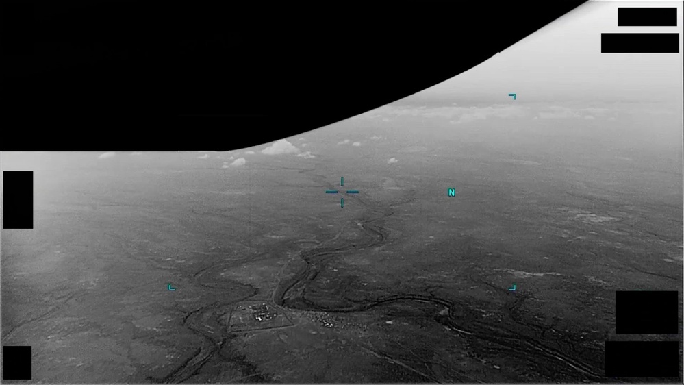
What is in frame is a wide oblique infrared view of desert. A branching dry channel network crosses the lower half of the picture, bending several times as it runs toward the centre, and a small compound with buildings and vehicle tracks sits near the lower left beside one of those bends. Cyan sensor symbology overlays the image: a crosshair near the centre, a north indicator, corner brackets. Rectangular black blocks cover the corners where a sensor data readout would normally sit, and the manifest flags this record with Redaction set to TRUE, so those blocks are deliberate. The upper left is a dark region meeting the bright ground along a rolled horizon, which is what a white hot infrared polarity does with cold sky over warm terrain. There is no aircraft in frame, no plume, no launch flash, no impact, no smoke.
The object is what the Department calls "a small, barely distinguishable area of contrast". The full official video description reads: "00:00-00:02: A small, barely distinguishable area of contrast moves from the left side of the sensor field-of-view to the right side, exiting the scene from the bottom right quarter of the screen." That is the whole government narrative. No reported shape, no size, no speed, no altitude, no conclusion.
Nandal and Loeb measured what the Department declined to. They tracked it across 13 centroids, frames 61 to 73 of the repeated cycle, an interval of 0.4004 seconds, with an apparent cross track width of about 3.8 full resolution pixels, which is unresolved or at best marginally resolved. Their headline measurement, and the one part of the work nobody in the subsequent argument disputes, is that the feature moves at about 801 pixels per second relative to the stabilised terrain. Everything else, the speed in metres per second, the size in metres, missile or bird, follows from converting that pixel motion into physical motion. That conversion needs the range to the target, and the range is exactly what the released clip does not contain.
What is the official explanation?
PR043 belongs to the first tranche of the Department of War's PURSUE releases, published on 8 May 2026. The archive pulled the official release manifest rather than relying on any secondary listing, and the PR043 row reads as follows. Title: "DOW-UAP-PR043, Unresolved UAP Report, Africa, 2025". Type: VID. Agency: Department of War. Incident Date: N/A. Incident Location: Djibouti. Redaction: TRUE. Release Date: 5/8/26. DVIDS Video ID: 1006159. The separate Video Title column reads "Unresolved UAP Report, Djibouti, 2025", so the Department itself uses the vaguer "Africa" in one column and the specific country in the other.
The two pairing columns, Video Pairing and PDF Pairing, are both empty. Those columns are how the Department cross links the records it treats as parts of a single incident, and how it points a video record at its paired mission report. Empty in both means two things at once: the government is asserting no link between PR043 and any other record in the corpus, and there is no declassified document behind this video. Whatever the reporting unit wrote up, if anything, has not been released. That is the difference between this case and, for example, the Greece 2023 record, where the paired mission report carries takeoff times, timestamps, an observer assessment and a grid reference.
The manifest blurb is the fullest official account: "The United States Africa Command submitted a report of an unidentified anomalous phenomenon to the All-domain Anomaly Resolution Office (AARO) consisting of two seconds of video footage from an infrared sensor aboard a U.S. military platform in 2025. The reporter did not provide any oral or written description of the observation." The record closes with the standard PURSUE disclaimer that readers "should not interpret any part of this description as reflecting an analytical judgment, investigative conclusion, or factual determination regarding the described event's validity, nature, or significance."
That is unusually thin even by PURSUE standards. The submitting command is US Africa Command. The platform is described only as "a U.S. military platform". There is no witness statement of any kind, because the reporter filed none. No altitude, no heading, no sensor type, no date beyond the year.
The DVIDS record backs it up and settles the tranche. Date Posted is 05.08.2026 at 07:50, placing it in the 8 May 2026 release, the first of the five published so far. Date Taken reads 01.01.2025 and the VIRIN is 250101-D-D0360-6307, whose date component 250101 is a first of January placeholder, the standing tell that day and month are not real and only the year is publishable. Location on DVIDS reads "(UNDISCLOSED LOCATION)", which is a little absurd when the manifest column two clicks away says Djibouti and the terrain is identifiable from public satellite imagery. The file is public domain, category B-Roll, length 00:00:11.
AARO's classification is in the title: unresolved. As of this file the archive has found no public statement from AARO, its director, or the Department of War responding to the Nandal and Loeb analysis, and none responding to the rebuttals of it. Nothing in the government record has moved since May.
What did the witnesses think it was?
There is no witness in this case. The reporter filed no description and no person is named anywhere in the official record. What exists instead is a set of named civilian analysts who looked at the same public file and reached different answers, and under this archive's rules that is the material that decides the tier.
Devesh Nandal is a Swiss National Science Foundation Postdoctoral Fellow at the Center for Astrophysics, Harvard and Smithsonian, working on stellar evolution models for massive stars. Avi Loeb is the Baird Professor of Science at Harvard and director of the Galileo Project, and since June 2026 he has chaired the UAP Science Advisory Council, a body that reports to the interagency UAP Governance Board and advises AARO. Nandal sits on that council too. Their paper, dated 6 August 2026 and hosted on Loeb's Harvard page, is titled "The PR043 Djibouti Video: Evidence for a Hypersonic-Missile Interpretation" and is bylined to the Galileo Project. Loeb summarised it the same day on Medium: "Amazingly, we were able to do better than AARO and resolve this case as a likely fast missile."
Their method is genuinely shown, which matters. They matched the terrain against Google Earth, placing the scene at 11.388655 N, 43.139259 E, which they describe as "near Goubetto in southern Djibouti" on a channel of the Damerjog drainage system, noting that despite looking like a river in infrared it "is more likely a dry wadi or an ephemeral channel". They registered the terrain frame to frame with a full time dependent homography, median registration error about 0.228 pixels across a median 1736 inlier matches, and tracked the target against that stabilised background. From a fitted camera model with a horizontal field of view of 65.6 degrees they placed the sensor 2.26 km above the local ground plane moving at about 77.7 metres per second, then intersected each viewing ray with a horizontal surface at a chosen altitude. That produces a family of answers rather than one: about 3.54 km per second if the object was on the deck, 1.94 at 1 km, 1.14 at 1.5 km, 0.34 at 2 km. A 3000 trial Monte Carlo on the ground plane solution gave a median of 3.37 km per second, 68 percent interval 2.88 to 4.02.
The hedges in that paper are heavy and they must be carried at full strength. The authors state that "A fast tactical missile or a short terminal missile passage is physically compatible with part of the conditional solution family." That "The short track does not show statistically significant acceleration or deceleration, so it cannot distinguish a powered missile from a sufficiently high ballistic-coefficient object that is coasting." That "The apparent-size estimate also does not identify a missile class." And that "The video provides no clear plume, launch context, impact, or independent target range." Their own acceleration test fitted 281.8 metres per second squared at an assumed 500 m altitude against a 95 percent null interval of minus 1148.9 to plus 1145.9, p equals 0.679, which is to say fully consistent with constant velocity.
On the other side is a group of analysts on Metabunk who had the case open three months earlier. The user flarkey geolocated the video to 11.388655 N, 43.139259 E on 12 May 2026, four days after the release, and identified a military compound at that point. On 8 August 2026 Mick West fitted the camera in his open source Sitrec tool and reported "VFOV is a hair under 33 degrees, HFOV is 55 degrees" with the camera at 1578 m above mean sea level rather than 2260 m above the ground plane, adding that this "invalidates all the numbers that follow in their paper, rendering it GIGO". On 9 August he posted a keyframed solution to X: "Adding keyframes to the 3D feature tracking shows that the object in the Pentagon's PR043 UFO video is consistent with a ~13 cm diameter object moving in level flight at 20 knots. Or any number of faster, larger objects. So maybe a bird, or a balloon." The member RobertBillyBob separately noted that the paper mentions parallax exactly once and dismisses it without showing the work, and that the widest field of view on the MTS-B sensor turret is 45 degrees, well short of 65.6.
There is also a priority dispute, on the record in both directions. flarkey emailed both authors on 10 August pointing out that six decimal places specify roughly an 11 cm square and that the paper cites nobody. Loeb replied the same day: "We were not aware of your analysis and never saw it. My postdoc, Dr. Devesh Nandal, derived them directly from the data on Google Earth and Google Maps. Your claim is similar to a mathematician claiming that whoever found that 2+2=4 must have copied the result from him." Nandal replied that the coordinate "is simply a convenient ground anchor within that matched scene", that his literature search covered arXiv, NASA ADS and the journals rather than forums, and that "we are happy to acknowledge and cite the earlier Metabunk geolocation if this work proceeds to journal publication". He also disclosed something absent from the paper: "I spoke to military personnel who had close knowledge of a U.S. base very close to this exact site." The archive takes no position on how the coordinate travelled. It records that the identical six decimal coordinate was published on Metabunk three months earlier, that the authors say they reached it independently, and that the paper cites nothing.
The location context cuts both ways. Camp Lemonnier is the only enduring US military installation in Africa and hosts AFRICOM's Combined Joint Task Force Horn of Africa, with over 5,000 US military and civilian personnel, per the Congressional Research Service country profile updated 9 June 2025, and the US built an airfield at Chabelley outside the capital in 2013 for its remotely piloted aircraft. The Metabunk analysts place the compound in the video roughly 20 km south of Camp Lemonnier, so a US platform running an infrared sensor over that desert needs no explaining. Whether anything local could produce a hypersonic object is another matter, and the forum's John J. worked it: a ground launched object on the implied track needs a minimum of around 1250 metres per second, Mach 3.67, and nothing in the Djiboutian inventory of artillery, cannon or portable missiles reaches that. The one regional actor with real ballistic and cruise missile reach is the Houthi movement across the Bab el Mandeb, assessed against Camp Lemonnier by Leonardo Jacopo Maria Mazzucco for Manara Magazine in July 2025, though that piece documents no strike on Djibouti itself.
Is the Djibouti Infrared UAP Video: DOW-UAP-PR043 and the Avi Loeb Missile Claim (2025) real? The two-pass assessment
Pass one, how could this be entirely ordinary. Very easily, and that is the point of the case rather than a strike against it.
The measured quantity is 801 pixels per second of image motion. Nothing else is measured. Turning that into a speed requires knowing how far away the object was, and the released clip carries no rangefinder data, no sensor metadata, no second angle and no parallax baseline long enough to triangulate on. Nandal and Loeb are explicit that their output is a family of conditional solutions rather than an answer: the reconstruction "leaves two broad regimes: a more distant and exceptionally fast object, or a closer and smaller object with a lower true speed". The second regime is the mundane one, and it is not a fringe corner of their own numbers. Their Table 1 shows the inferred speed collapsing to 0.34 km per second at an assumed 2 km altitude, which is roughly where they put the sensor, and a forum reader drew the obvious consequence: two hundred metres higher and the object is essentially stationary, which is to say a balloon, a bird, or an insect near the lens. A small change in the one unknown parameter swings the answer from hypersonic weapon to litter on the wind.
Mick West's keyframed fit lands in exactly that regime, about 20 knots for an object roughly 13 cm across, and he says plainly that faster and larger objects fit too. He is disputing the input to the whole chain rather than the arithmetic downstream of it: 55 degrees of horizontal field of view against the paper's 65.6, and a camera 700 metres lower. If West's camera is right, the paper's velocities are wrong by a large factor and the missile reading evaporates. If the paper's camera is right, West's is wrong and the hypersonic branch stays open. Nobody has adjudicated it, and nobody can from the released file alone, because the sensor intrinsics are precisely what the Department redacted.
The missile reading also carries a problem the authors raise and do not solve. Their own aerodynamic test punishes the low altitude hypersonic branch hard: Mach 8.12 and 4.407 MPa of dynamic pressure at an assumed 500 m, with a relative heating index 4.8 times their reference condition. Sustained flight there is very difficult. They rescue it by proposing a brief terminal passage, allowed because the track lasts only 0.4 seconds, but that is a hypothesis fitted to the difficulty rather than a result the data forced.
Pass two, what survives if none of the ordinary readings holds. Less than the headline suggests, and the paper says so more plainly than the coverage of it did. Its conclusion is that "The strongest interpretation supported by the present reconstruction is therefore a fast tactical missile or terminal missile passage", followed immediately by the qualification that "the released clip does not determine the target range, propulsion state, or specific missile type" and that "The unavailable sensor intrinsics and the unresolved target image prevent a unique speed, physical size, or named-system identification." A missile is compatible. So is a bird. So is something nearly stationary at the sensor's own altitude. The video does not choose.
What is genuinely new here is not an identification but a method, and a fight about it. Nobody had previously turned a PURSUE clip into a bounded velocity family by using the ground itself as the coordinate system and publishing every stage with its uncertainties. Whether or not the camera model holds, the registration is checkable, the Monte Carlo is described, the null test is described, and a rival analyst could attack it on specifics inside 48 hours precisely because the work was shown. That is how this is supposed to go, even if neither side has been especially gracious about it.
One complication has to be said out loud rather than buried. This archive credits independent civilian analysis against a case and does not credit official debunks, on the grounds that the apparatus explaining away its own material is evidence the material needed closing. Loeb chairs the UAP Science Advisory Council, which advises AARO, and Nandal sits on it. Their paper does not come from that council, it is bylined to the Galileo Project and published on Loeb's Harvard page and his blog with no government imprimatur, and it reaches a conclusion more deflationary than AARO's own. That is not disqualifying and this file does not treat it as such, but it is not the same as a wholly disinterested outsider, and readers deserve to know. Nandal's disclosure that he cross checked the site with "military personnel who had close knowledge of a U.S. base very close to this exact site", a source appearing nowhere in the paper, belongs in the same bracket.
The tier. The official record says unresolved and has not moved. Against it stands a named, quantitative, published analysis showing its method and concluding that a fast tactical missile is physically compatible with part of its own solution family. That is a real evidenced counter explanation and it earns a disputed tier. It is not more than that. The same paper says the track shows no statistically significant acceleration, that it cannot separate a powered missile from a coasting one, that the size estimate identifies no missile class, and that there is no plume, no launch context, no impact and no independent range. A second named analyst has attacked the camera model the whole reconstruction rests on and produced a 20 knot bird or balloon solution from the same footage. So the case is Disputed, and the honest summary is that two seconds of redacted infrared video will support a hypersonic missile and a pigeon with roughly equal comfort, and that it stays that way until somebody releases the sensor metadata.
Sources
- www.dvidshub.net/video/1006159/dow-uap-pr43-unresolved-uap-report-africa-2025
- web.archive.org/web/20260808030642id_/https://www.war.gov/Portals/1/Interactive/2026/UFO/uap-data.csv?release=5
- lweb.cfa.harvard.edu/~loeb/NL26.pdf
- avi-loeb.medium.com/the-declassified-dow-uap-pr043-in-the-pursue-disclosure-is-likely-a-missile-4d4116776c85
- www.metabunk.org/threads/pr043-africa-djibouti.14885/
- www.metabunk.org/threads/pr043-africa-djibouti.14885/page-2
- x.com/MickWest/status/2086589734848168249
- defensescoop.com/2026/06/17/new-science-advisory-council-forms-to-help-us-government-resolve-the-uap-mystery/
- web.archive.org/web/20260303225212/https://itc.cfa.harvard.edu/people/devesh-nandal
- www.congress.gov/crs_external_products/IF/PDF/IF11303/IF11303.8.pdf
- manaramagazine.org/2025/07/assessing-the-houthi-threat-to-camp-lemonnier-in-djibouti/
- d34w7g4gy10iej.cloudfront.net/video/2605/DOD_111689759/DOD_111689759.mp4
More cases from this region: UFO sightings in Djibouti